MORE CARTOGRAPHY
your picture here
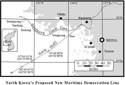
Some political scientists asked me to create this map to illustrate an article giving both sides of the dispute over the maritime line dividing North and South Korea. I created it with a scholarly journal in mind, but they submitted it to the International Herald Tribune, which took out the map and one side of the argument, publishing the remainder on the opinion page.
your picture here
World Average July Temperatures. I created this in order to replace a copyrighted map in the lab manual for our introductory physical geography class.
your picture here
Hurricanes and Tropical Storms Threatening Hawaii in the Last 45 Years. Another illustration from the physical geography lab manual.
powered by lycos
SEARCH: Tripod The Web